


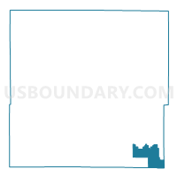
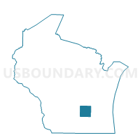
ASHIPPUN - T 2 Voting District, Dodge County, Wisconsin
About
Outline

Summary
| Unique Area Identifier | 693317 |
| Name | ASHIPPUN - T 2 Voting District |
| County | Dodge County |
| State | Wisconsin |
| Area (square miles) | 15.63 |
| Land Area (square miles) | 15.55 |
| Water Area (square miles) | 0.08 |
| % of Land Area | 99.47 |
| % of Water Area | 0.53 |
| Latitude of the Internal Point | 43.22920340 |
| Longtitude of the Internal Point | -88.47519040 |
Maps

Graphs
Select a template below for downloading or customizing gragh for ASHIPPUN - T 2 Voting District, Dodge County, Wisconsin


Neighbors
Neighoring Voting District (by Name) Neighboring Voting District on the Map
- ASHIPPUN - T 1 Voting District, Dodge County, WI
- ASHIPPUN - T 3 Voting District, Dodge County, WI
- ERIN - T 4 Voting District, Washington County, WI
- LEBANON - T 1 Voting District, Dodge County, WI
- LEBANON - T 2 Voting District, Dodge County, WI
- MERTON - T 4 Voting District, Waukesha County, WI
- OCONOMOWOC - T 1 Voting District, Waukesha County, WI
- OCONOMOWOC - T 4 Voting District, Waukesha County, WI
Top 10 Neighboring County Subdivision (by Population) Neighboring County Subdivision on the Map
- Oconomowoc town, Waukesha County, WI (8,408)
- Merton town, Waukesha County, WI (8,338)
- Erin town, Washington County, WI (3,747)
- Ashippun town, Dodge County, WI (2,559)
- Lebanon town, Dodge County, WI (1,659)
Top 10 Neighboring Elementary School District (by Population) Neighboring Elementary School District on the Map
- Hartford Joint No. 1 School District, WI (17,741)
- Stone Bank School District, WI (2,647)
- Neosho Joint No. 3 School District, WI (1,998)
Top 10 Neighboring Secondary School District (by Population) Neighboring Secondary School District on the Map
Top 10 Neighboring Unified School District (by Population) Neighboring Unified School District on the Map
Top 10 Neighboring State Legislative District Lower Chamber (by Population) Neighboring State Legislative District Lower Chamber on the Map
Top 10 Neighboring State Legislative District Upper Chamber (by Population) Neighboring State Legislative District Upper Chamber on the Map
Top 10 Neighboring 111th Congressional District (by Population) Neighboring 111th Congressional District on the Map
Top 10 Neighboring Census Tract (by Population) Neighboring Census Tract on the Map
- Census Tract 9615, Dodge County, WI (5,220)
- Census Tract 9616, Dodge County, WI (4,412)
- Census Tract 4401.06, Washington County, WI (3,747)
- Census Tract 2045.01, Waukesha County, WI (2,495)